Florida’s Weekend Forecast Just Took a Wild Turn — Here’s What You Need to Know
Florida’s weather is flipping the switch again — and fast. With a Florida Weather ALERT in effect, Tampa residents are being urged to brace for two big changes starting Thursday: a spike in heat, and a rising risk of strong weekend storms. It’s the kind of classic spring-to-summer collision that can catch people off guard if they’re not paying attention.
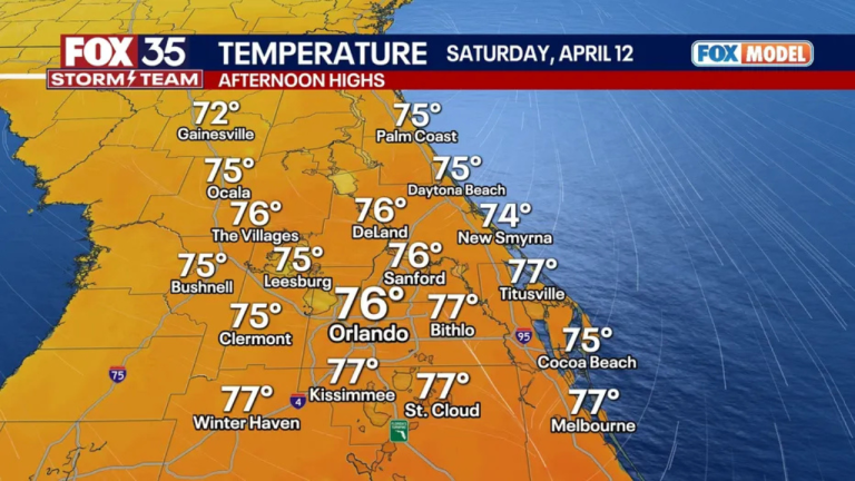
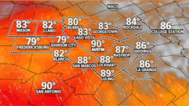
Thursday will usher in some of the hottest temperatures we’ve seen so far this season, with the mercury expected to hit 90°F or higher. Combine that with Florida’s signature humidity, and the air will feel downright sweltering — especially during the afternoon hours.
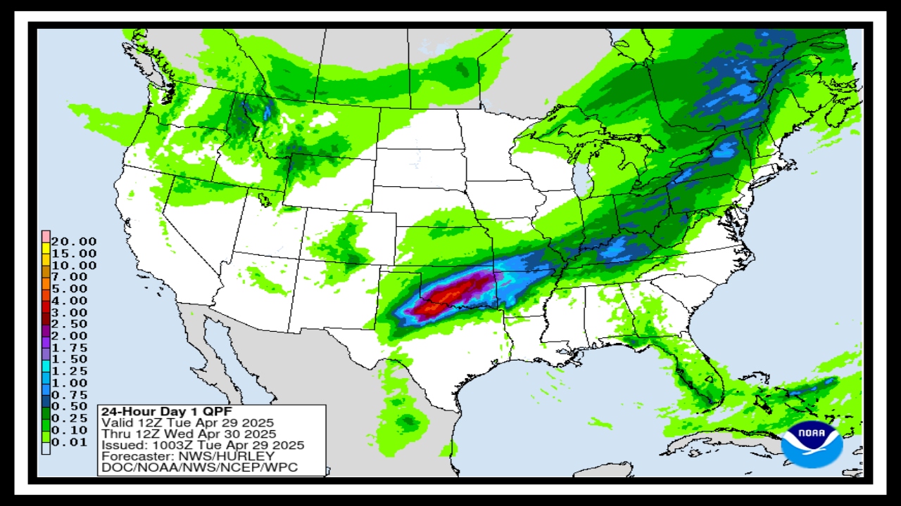
But this isn’t just about sweating through a few hot days. The heat is laying the groundwork for something more serious heading into the weekend: thunderstorms. And not just the passing kind — we’re talking potentially strong systems capable of heavy rain, lightning, gusty winds, and localized flooding.
What the Florida Weather ALERT Means for You
This heatwave isn’t here to stay long, but it’s intense enough to matter — especially for young kids, the elderly, or anyone working or playing outside. By Friday night into Saturday, a cold front will begin pushing across the state, setting off widespread thunderstorms as it meets the warm, moist air mass already in place.
Here’s what Tampa and the I-4 corridor can expect:
-
Afternoon heat indexes in the mid to upper 90s
-
Strong thunderstorms Saturday and Sunday, with chances of:
-
Heavy rainfall and possible flash flooding in urban and low-lying areas
-
Wind gusts topping 40–50 mph, enough to knock over lightweight objects
-
Dangerous cloud-to-ground lightning
-
Isolated power outages, especially in storm-prone neighborhoods
-
This Florida Weather ALERT serves as more than just a heads-up — it’s a nudge to take simple but effective precautions.
How to Stay Safe and Beat the Heat + Storm Combo
Now’s the time to prepare. Here are a few smart tips to make it through this pattern safely and comfortably:
-
Hydrate early and often — Don’t wait until you’re thirsty.
-
Reschedule outdoor activities — If you can, shift plans to the morning or early evening.
-
Secure outdoor items — Trash bins, patio furniture, and pool gear could become airborne with high winds.
-
Watch the skies and your apps — Thunderstorms can develop quickly in Florida. Real-time weather alerts are your best friend.
-
Charge your phone and backup battery packs — Just in case a power outage hits.
Looking Ahead
Once the front clears, cooler and drier air will return early next week, bringing some relief from both the heat and the storms. But Florida’s spring weather is famously unpredictable, so staying weather-aware is a smart habit — especially as we move closer to hurricane season.
FAQ About Florida’s Weekend Forecast
1. What’s going on with this Florida Weather ALERT — should I be worried?
Not panicking territory, but definitely something to pay attention to. Tampa’s heating up with temps hitting the 90s starting Thursday — and by the weekend, things could turn stormy. We’re talking thunderstorms, heavy rain, and the chance of flooding. It’s a classic Florida mix of heat and storms, just a bit more intense than usual.
2. When should I expect the worst of it?
The real heat kicks in Thursday and Friday, so expect those muggy, uncomfortable afternoons. But the real weather action? That’s likely to hit late Saturday into Sunday — when all that heat and humidity meets a cold front. Boom: storms. Timing can change, so keep an eye on your weather app or local updates.
3. How can I stay safe with this kind of weather coming?
A few quick things go a long way:
-
Drink water and stay inside during peak heat hours.
-
Tie down or bring in loose outdoor items before Saturday.
-
Charge up your phone and flashlights in case the power goes out.
-
And if it’s pouring out, maybe rethink that weekend drive — especially in low-lying areas that flood easily.
4. Are we looking at flooding or outages?
It’s definitely possible. Some areas could see quick street flooding if the rain hits hard and fast. Gusty winds could knock out power for a bit too — nothing unusual for Florida storms, but enough to be ready with backup plans.
5. Will next week be any better?
Thankfully, yes! Once this system moves through, early next week should feel like a breath of fresh air — slightly cooler, less humid, and much more pleasant. A perfect reminder that Florida weather always has its ups and downs.